Pakistan’s geography is visually powerful; but also complex. From the world’s highest mountain ranges to fertile plains, deserts, and coastal belts, the country’s terrain cannot be fully understood through flat maps or digital screens alone. This becomes a real challenge for educators, institutions, architects, museums, and organizations that need to display, explain, or present Pakistan’s geography clearly.
The problem is simple:
2D maps fail to communicate elevation, depth, and scale.
That’s why compact and large Pakistan 3D terrain relief maps, created as precise 3D Architectural Models, have become essential display solutions.
At BD3D, a specialist in 3D Architectural Model Making & Manufacturing, we produce on-demand Pakistan 3D terrain relief maps in both compact and large formats, designed for clarity, accuracy, and visual impact.
Why Displaying Pakistan’s Terrain Is a Real Challenge
Pakistan’s terrain directly influences climate, agriculture, infrastructure, water systems, and urban development. Yet most display solutions oversimplify this complexity.
Common Display Problems
- Flat maps lack depth and elevation
- Digital screens fail to engage viewers
- Large regions look confusing without scale
- Mountains and valleys are hard to explain verbally
- Displays lack long-term visual impact
For exhibitions, offices, classrooms, and public spaces, these limitations reduce understanding instead of enhancing it.
A physical Pakistan 3D terrain relief map solves this problem instantly.
What Is a Pakistan 3D Terrain Relief Map?
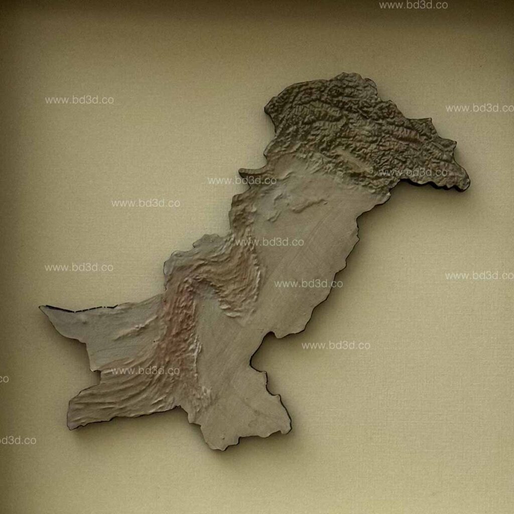
A Pakistan 3D terrain relief map is a physical, scaled model that accurately represents the country’s topography using real elevation data.
Built as 3D Architectural Models, these maps show:
- Mountain ranges in true relief
- Plains, plateaus, and deserts clearly
- River systems and valleys accurately
- Real spatial relationships between regions
Unlike digital visuals, a physical terrain map allows viewers to understand geography at a glance, without explanation or technical knowledge.
Compact vs Large Pakistan 3D Terrain Relief Maps: Which Do You Need?
Choosing the Right Size for 3D Architectural Models
Different display environments require different solutions. At BD3D, we offer both compact and large Pakistan 3D terrain relief maps, each designed to solve specific display challenges.
Compact Pakistan 3D Terrain Relief Maps
Compact terrain models are ideal when space is limited but clarity is still essential.
Best For:
- Office desks and meeting rooms
- Small exhibitions and galleries
- Educational classrooms
- Personal or corporate displays
Key Advantages:
- Easy to place and transport
- Cost-effective display solution
- Clean and minimal presentation
- Still shows clear elevation and terrain variation
Despite their size, compact 3D Architectural Models are carefully scaled to ensure terrain accuracy is never compromised.
Large Pakistan 3D Terrain Relief Maps
Large terrain models are designed for maximum impact and visibility.
Best For:
- Museums and permanent exhibitions
- Government and institutional spaces
- University halls and auditoriums
- Corporate lobbies and public displays
Key Advantages:
- Highly detailed terrain representation
- Strong visual presence
- Easy for large audiences to understand
- Ideal for presentations and storytelling
Large-scale 3D Architectural Models allow viewers to explore Pakistan’s geography in depth, making them powerful educational and display tools.
Why 3D Architectural Models Are Ideal for Terrain Displays
Terrain relief mapping requires more than basic fabrication. Accuracy, scale, and durability are essential, especially for long-term displays.
What 3D Architectural Models Offer
- Precise scale and proportional accuracy
- Correct elevation representation
- Structural strength for permanent display
- Professional finishing and detailing
By applying architectural modeling standards, BD3D ensures each Pakistan terrain relief map is not only visually impressive but also reliable and informative.
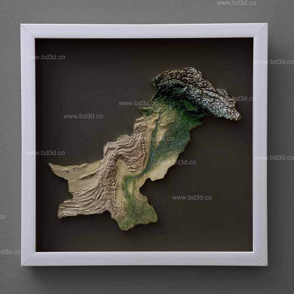
Pakistan’s Geography Explained Through 3D Architectural Models
Pakistan is home to some of the world’s most dramatic and varied terrain. Representing this diversity accurately is only possible through physical relief models.
Key Features Shown Clearly
- Karakoram, Hindu Kush, and Himalayan ranges
- Indus River system and tributaries
- Punjab plains and agricultural zones
- Balochistan plateau and deserts
- Coastal regions along the Arabian Sea
A well-crafted Pakistan 3D terrain relief map turns complex geography into an easy-to-understand visual story.
How BD3D Creates Pakistan 3D Terrain Relief Maps
Our Process for 3D Architectural Models
At BD3D, our process focuses on one goal: turning complex terrain into clear, accurate physical models.
Step 1: Accurate Terrain Data Collection
We start with reliable, real-world elevation and geographic data to ensure:
- Correct mountain heights
- Accurate valleys and plains
- Realistic terrain transitions
Step 2: Digital Terrain Modeling
Our designers convert raw data into refined digital models by:
- Cleaning elevation data
- Adjusting scale for display clarity
- Preparing files for physical production
This step ensures the final 3D Architectural Models are accurate before manufacturing begins.
Step 3: Precision Manufacturing
Using advanced fabrication methods, we produce:
- Clean terrain layers
- Sharp topographic detail
- Strong, stable bases
These models are built to last, even in high-traffic display environments.
Step 4: Hand Finishing and Display Preparation
Each terrain relief map is hand-finished with:
- Natural or custom color palettes
- Highlighted ridges, valleys, and plains
- Optional framing or mounting
This final stage ensures the model is ready for professional display.
Who Uses Compact and Large Pakistan 3D Terrain Relief Maps?
Pakistan 3D terrain relief maps are used across multiple sectors.
Common Users
- Educational Institutions: Geography and environmental studies
- Museums & Exhibitions: Interactive geographic displays
- Architects & Urban Planners: Regional context understanding
- Government Offices: Infrastructure and planning visualization
- Corporate Spaces: High-impact cultural and geographic displays
In every case, the goal is clarity, engagement, and understanding.
Why Physical Terrain Models Outperform Digital Displays
The Display Advantage of 3D Architectural Models
Digital maps are useful, but they often fail to engage non-technical audiences.
Key Advantages of Physical Models
- Immediate depth perception
- No screens or software required
- Easy for all age groups to understand
- Strong visual and educational impact
- Long-term, reusable display solution
A physical Pakistan 3D terrain relief map becomes a permanent communication asset; not a temporary visual.
Customization Options Available at BD3D
As an on-demand 3D Architectural Model Making & Manufacturing company, BD3D offers extensive customization.
Custom Options Include:
- Compact or large model sizes
- Wall-mounted or tabletop formats
- Framed or freestanding displays
- Natural, monochrome, or artistic finishes
- Optional geographic labeling
This flexibility ensures your terrain relief map fits your space and purpose perfectly.
Accuracy and Durability in 3D Architectural Models
Poorly made terrain models often suffer from:
- Incorrect elevation
- Fragile construction
- Misleading proportions
At BD3D, accuracy and durability are priorities. Each model is reviewed for:
- Scale consistency
- Structural stability
- Visual clarity
This ensures your Pakistan 3D terrain relief map remains reliable for years.
Pakistan 3D Terrain Relief Maps as Educational and Cultural Displays
Beyond technical use, these models also serve as:
- Educational tools for students
- Cultural representations of Pakistan’s landscape
- Conversation-starting display pieces
They allow people to connect with geography in a tangible, memorable way.
Why Choose BD3D for Pakistan 3D Terrain Relief Maps
Choosing the wrong supplier can result in inaccurate or low-quality models.
BD3D Solves This By Offering:
- Professional expertise in 3D Architectural Models
- On-demand custom manufacturing
- High-quality materials and finishing
- Attention to detail from start to finish
Our experience in 3D Architectural Model Making & Manufacturing ensures every project delivers value and clarity.
Final Thoughts
Pakistan’s geography deserves more than flat visuals. Its mountains, plains, deserts, and rivers require depth, scale, and physical presence to be truly understood.
A compact or large Pakistan 3D terrain relief map, created as a professional 3D Architectural Model, provides that clarity.
At BD3D, we specialize in on-demand terrain relief models designed for display, education, and professional use, helping organizations turn complex geography into clear visual understanding.
If you are looking for compact or large Pakistan 3D terrain relief maps built as accurate 3D Architectural Models, BD3D delivers precision, durability, and impact.