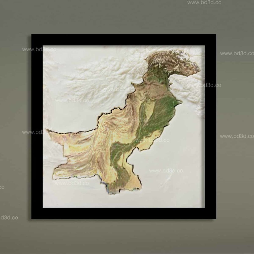
Understanding Pakistan’s geography is not always easy when relying only on flat maps or digital screens. Administrative boundaries, mountain ranges, river systems, and urban centers often overlap visually, creating confusion instead of clarity. This is where Pakistan Official Map created as 3D Architectural Models becomes a powerful solution.
At BD3D, a professional 3D Architectural Model Making & Manufacturing company, official maps of Pakistan are transformed into highly accurate, physical 3D models that bring geography to life. These models help institutions, professionals, educators, and decision-makers see Pakistan’s landscape in a clearer, more engaging way.
Why Flat Maps Are No Longer Enough
Traditional printed maps and digital visuals have limitations that create real problems for users:
- Elevation and terrain appear flat and unrealistic
- Borders and regions blend together visually
- Scale is difficult to understand
- Spatial relationships are hard to explain to non-experts
For planners, educators, developers, and government bodies, these issues can lead to misunderstandings and poor communication.
3D Architectural Models solve this problem by turning abstract data into physical clarity.
What Is a Pakistan Official Map in 3D Architectural Models?
A Pakistan Official Map created as a 3D Architectural Model is a physical, scaled representation of the country that accurately reflects:
- National and provincial boundaries
- Major cities and infrastructure
- Mountain ranges such as the Karakoram, Himalayas, and Hindu Kush
- Rivers including the Indus Basin system
- Coastlines, plains, deserts, and plateaus
Unlike decorative maps, official 3D maps are created using verified geographic and elevation data, ensuring accuracy and professional usability.
Why Pakistan Official Maps Matter for Institutions and Professionals
Pakistan’s geography plays a critical role in planning, development, education, and governance. When geography is misunderstood, projects suffer.
Common Challenges Faced by Map Users
Many organizations struggle with:
- Explaining terrain impact on infrastructure projects
- Presenting data to non-technical stakeholders
- Teaching geography in an engaging way
- Displaying Pakistan’s national landscape professionally
A Pakistan Official Map built as a 3D Architectural Model directly addresses these challenges.
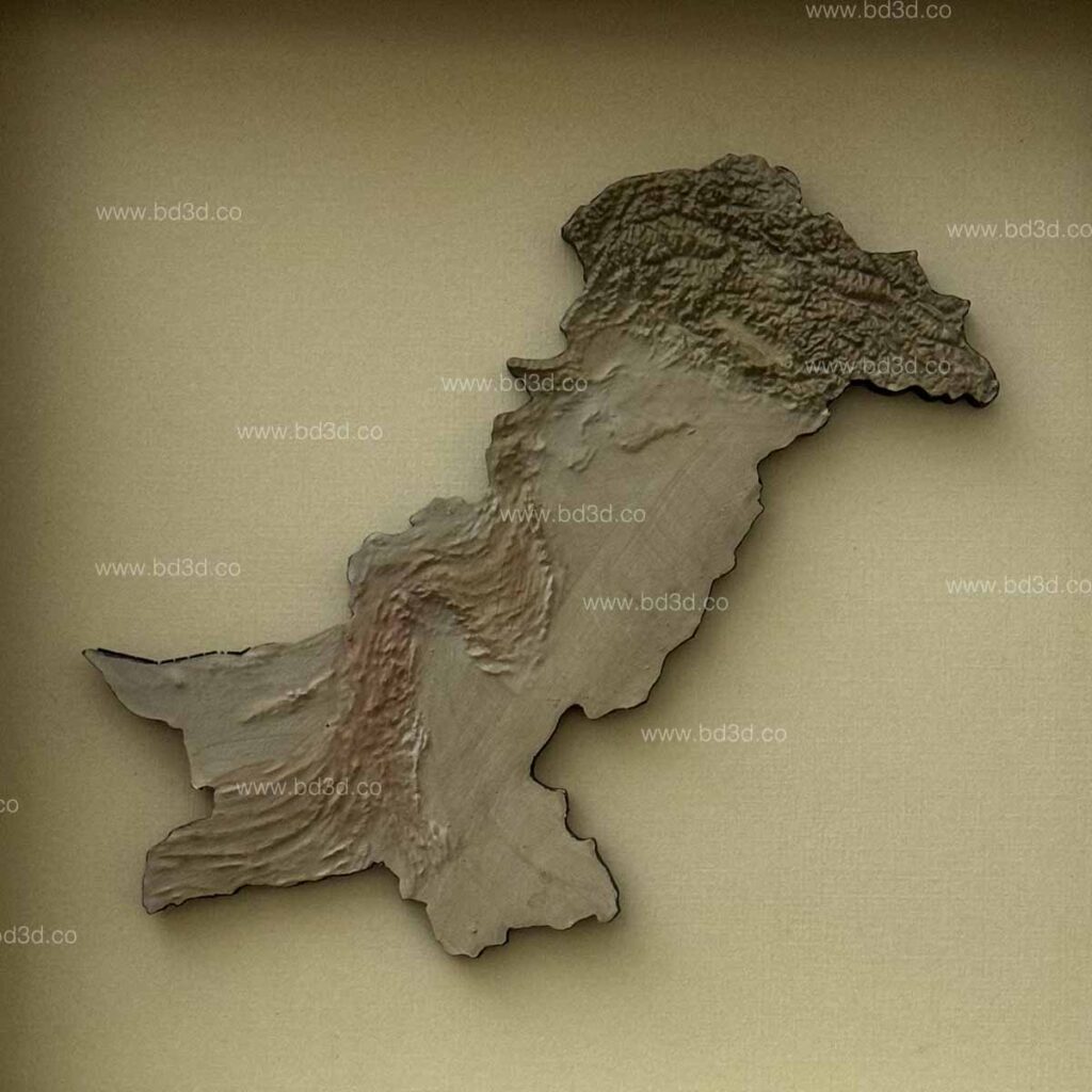
How BD3D Creates Accurate Pakistan Official 3D Maps
BD3D is not a generic model supplier. As a specialized 3D Architectural Model Making Company, BD3D follows a precise, data-driven process.
Data Accuracy Comes First
Every Pakistan Official Map is developed using:
- Official geographic references
- Satellite elevation data
- Verified boundary information
- Scaled topographic inputs
This ensures the final 3D Architectural Model reflects real-world conditions, not approximations.
Precision Manufacturing Process
BD3D combines:
- CNC machining
- High-resolution 3D printing
- Hand-finishing by skilled model makers
This hybrid approach allows for crisp details, clean edges, and durable results suitable for long-term display.
Problem: Oriented Use Cases of Pakistan Official 3D Maps
Rather than focusing on tools, let’s look at real problems these models solve.
Education and Academic Institutions
Problem:
Students struggle to understand Pakistan’s diverse terrain using textbooks alone.
Solution:
A Pakistan Official Map in 3D Architectural Models allows learners to:
- Visually grasp elevation changes
- Understand river systems and mountain ranges
- Connect geography with climate and population
Government & Policy Planning
Problem:
Policy discussions become abstract without physical reference points.
Solution:
3D Architectural Models provide:
- Clear visualization during planning sessions
- Better communication between departments
- Improved public presentations
Corporate Offices & Boardrooms
Problem:
Flat maps fail to reflect national scale and importance.
Solution:
A professionally crafted Pakistan Official Map enhances:
- Corporate interiors
- Strategic presentations
- Brand authority and credibility
Display Value of Pakistan Official 3D Architectural Models
These models are not only informative; they are visually striking.
Ideal Display Locations
- Government buildings
- Universities and schools
- Corporate headquarters
- Museums and exhibitions
- Real estate and infrastructure firms
The combination of depth, scale, and craftsmanship makes these models conversation-starting centerpieces.
Customization Options Offered by BD3D
Every organization has different needs. BD3D offers on-demand customization to solve specific problems.
Custom Features Available
- Size scaling (compact to large formats)
- Deep frames or wall-mounted options
- Color-coded regions or provinces
- Labeling for cities, rivers, or infrastructure
- Branding for institutions or exhibitions
These options ensure the 3D Architectural Models fit both functional and aesthetic requirements.
Why Choose BD3D as Your 3D Architectural Model Making Company
Choosing the right partner matters. BD3D stands out because of its focus on accuracy, craftsmanship, and problem-solving.
Key Strengths of BD3D
- Specialized in architectural and geographic models
- On-demand manufacturing flexibility
- Experienced model makers and engineers
- Global client servicing
- Consistent quality standards
BD3D does not sell generic products; it delivers purpose-built 3D Architectural Models that solve real visualization challenges.
Pakistan Official Map vs Decorative Map: Key Differences
| Feature | Decorative Maps | Pakistan Official 3D Maps |
|---|---|---|
| Accuracy | Low | High |
| Elevation Detail | Flat | True 3D terrain |
| Professional Use | Limited | Extensive |
| Customization | Minimal | Fully customizable |
| Manufacturing | Mass-produced | On-demand |
For serious applications, 3D Architectural Models are the clear choice.
Future Demand for 3D Architectural Models in Geographic Visualization
With growing emphasis on:
- Infrastructure development
- Urban planning
- Climate and environmental studies
- Educational modernization
The demand for official geographic 3D models is increasing worldwide. Pakistan is no exception.
Organizations are moving away from static visuals toward immersive, physical models that improve understanding and decision-making.
Final Thoughts: Turning Geography into Understanding
A Pakistan Official Map created as a 3D Architectural Model is more than a display piece, it is a communication tool, an educational aid, and a strategic asset.
By transforming Pakistan’s geography into a precise physical form, BD3D helps institutions overcome confusion, improve clarity, and present information with confidence.
If your organization needs a reliable, professional, and visually powerful way to represent Pakistan’s geography, partnering with an experienced 3D Architectural Model Making Company like BD3D is the solution.