Understanding Afghanistan’s geography is a challenge for many professionals. The country is defined by dramatic mountain ranges, complex valleys, deserts, and strategic passes that have shaped its history, infrastructure, and development. Yet, most people still rely on flat maps or digital screens to interpret this terrain, tools that often fail to explain elevation, scale, and spatial relationships clearly.
This is where Afghanistan 3D Maps created by professional Architectural Model Makers provide a real solution.
At BD3D, a specialist in 3D Architectural Model Making & Manufacturing, we create on-demand Afghanistan 3D maps that turn complex terrain into clear, physical, and accurate models designed for understanding, presentation, and long-term use.
Why Afghanistan’s Geography Is Hard to Understand Using Flat Maps
Afghanistan is one of the most topographically complex countries in the region. The Hindu Kush mountain system alone dominates much of the landscape, influencing climate, transportation, settlement patterns, and security.
The Common Problems People Face
- Mountains and valleys look flat on 2D maps
- Elevation changes are difficult to visualize
- Scale is often misunderstood
- Geographic features lack context
- Digital maps lose impact in presentations
For educators, planners, researchers, museums, and institutions, these limitations create confusion instead of clarity.
The Real Need
People don’t just want data; they want understanding. This is why physical terrain models, built by experienced Architectural Model Makers, are becoming essential tools rather than optional displays.
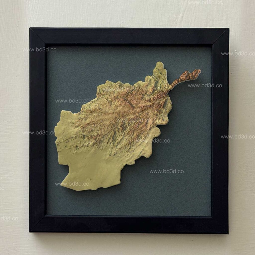
What Is an Afghanistan 3D Map?
An Afghanistan 3D Map is a physical, scaled terrain model that accurately represents the country’s topography, elevation, and landforms using real-world geographic data.
Unlike digital renders or printed maps, a physical 3D model allows viewers to:
- Instantly see elevation differences
- Understand mountain systems and valleys
- Grasp spatial relationships without explanation
- Engage visually and physically with the geography
At BD3D, each Afghanistan 3D map is produced on demand, ensuring it meets the specific purpose of the client, whether educational, institutional, or display-based.
Why Architectural Model Makers Are Essential for Terrain Accuracy
Creating a detailed terrain model is not the same as basic 3D printing. It requires deep understanding of scale, proportion, materials, and visual communication.
What Architectural Model Makers Do Differently
Professional Architectural Model Makers bring:
- Precision in scale and proportion
- Experience with complex physical forms
- Knowledge of durable materials
- Ability to balance accuracy with visual clarity
This expertise is crucial when working with a country like Afghanistan, where even small errors in elevation or proportion can distort understanding.
As a specialized manufacturer, BD3D applies architectural modeling standards to terrain projects, ensuring reliability and realism.
How BD3D Creates Afghanistan 3D Maps with Amazing Terrain Detail
Our Process as Architectural Model Makers
At BD3D, our workflow focuses on solving one core problem: making complex geography easy to understand.
Step 1: Real Terrain Data Collection
We begin by sourcing accurate and up-to-date topographic and elevation data to ensure:
- Correct mountain heights
- Accurate valleys and plains
- Realistic slope transitions
This step is critical to avoid exaggerated or misleading terrain.
Step 2: Digital Terrain Modeling
Our designers convert raw data into refined digital terrain models by:
- Cleaning elevation data
- Adjusting scale for clarity
- Ensuring proportional accuracy
This digital phase allows precision before physical production begins.
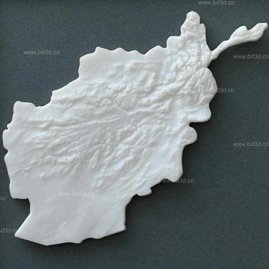
Step 3: Physical Model Manufacturing
Using advanced fabrication techniques, our Architectural Model Makers create:
- Clean, layered terrain surfaces
- Sharp geographic details
- Strong, stable base structures
Every model is built for long-term use and display.
Step 4: Hand Finishing and Detailing
Final finishing includes:
- Hand-painted terrain colors
- Highlighted mountain ridges and valleys
- Custom visual styles based on client needs
This handcrafted stage is what gives BD3D models their premium quality.
Who Needs an Afghanistan 3D Map?
Afghanistan 3D maps are used by a wide range of professionals who need more than just visual decoration.
Common Use Cases
- Educational Institutions: Teaching geography, history, and geopolitics
- Museums & Exhibitions: Engaging, interactive displays
- Research & Think Tanks: Physical reference tools
- Government & Strategic Studies: Terrain understanding
- Collectors & Cultural Displays: High-quality geographic artifacts
In all these cases, the goal is the same: clear communication of complex terrain.
The Advantages of Physical 3D Maps Over Digital Tools
Why Architectural Model Makers Still Matter in a Digital World
While digital maps are convenient, they often fail to leave a lasting impression.
Key Advantages of Physical 3D Models
- No learning curve for viewers
- Immediate depth and scale understanding
- Strong engagement during presentations
- Works without screens or software
- Long-lasting and reusable
A physical model created by Architectural Model Makers becomes a permanent communication tool, not a temporary visual.
Customization Options Offered by BD3D
As an on-demand 3D Architectural Model Making & Manufacturing company, BD3D offers complete customization.
Customization Includes:
- Model size and scale
- Framed or tabletop formats
- Natural or stylized color schemes
- Geographic labeling (optional)
- Wall-mounted or freestanding displays
This flexibility allows clients to order models that fit their space, audience, and purpose perfectly.
Accuracy and Reliability: Why Data Matters in Terrain Models
One of the biggest risks in terrain modeling is inaccuracy. Poorly built models can:
- Misrepresent geography
- Create misunderstanding
- Reduce educational value
At BD3D, accuracy is a priority. Our Architectural Model Makers ensure:
- Proportional elevation
- Consistent scaling
- Careful data interpretation
This commitment makes BD3D a trusted partner for professional terrain modeling projects.
Afghanistan 3D Maps as Educational and Display Solutions
Beyond technical applications, Afghanistan 3D maps also serve as:
- Powerful teaching tools
- Cultural and geographic displays
- Conversation-starting installations
They help audiences connect with geography in a way that feels tangible and memorable.
Why Choose BD3D as Your Architectural Model Makers
Choosing the right model maker is critical. Poor craftsmanship can lead to fragile models, inaccurate terrain, and wasted investment.
BD3D Solves These Problems By Offering:
- Experienced Architectural Model Makers
- On-demand custom production
- High-quality materials
- Attention to detail at every stage
Our expertise in 3D Architectural Model Making & Manufacturing ensures each Afghanistan 3D map delivers real value—not just visual appeal.
Final Thoughts
Afghanistan’s geography cannot be fully understood through flat maps alone. Its mountains, valleys, and terrain require depth, scale, and physical presence to be truly appreciated.
An Afghanistan 3D Map by Architectural Model Makers provides that clarity.
At BD3D, we specialize in creating terrain models that transform complex geographic data into accurate, easy-to-understand physical forms. Whether for education, research, exhibition, or display, our on-demand 3D maps are built to solve real communication challenges.
If you are looking for expert Architectural Model Makers to create an Afghanistan 3D map with amazing terrain detail, BD3D delivers precision, reliability, and impact.